Detour #139: Touring Turkey’s treacherous but beautiful borderlands

Erin O’Brien takes a trip through the ancient and modern ruins of south east Turkey where danger and beauty sit side by side.
For many in Turkey, the region stretching along the Syrian border is formidable, violent country. Admittedly, the region has seen its share of violence – it was, indeed, the site of border conflict between Western mandate powers and Turkey at the beginning of the 20th century, and has been the site of conflict with the Kurdistan Workers’ Party (PKK) and ISIS since.
The scars are many, and some are fresh. But to focus only on the turmoil in the region is to ignore the depth of its history. The layered remnants of the overlapping civilizations – Armenian, Assyrian, Persian, Roman, Artuklu, Kurdish, to name a few – are buried here. Their ruins define the landscape, and their practices continue to shape everyday life. It’s a place where at every turn, one can discover something remarkable. In other words, it’s the perfect place for a road trip.
Begin in Diyarbakir, the largest, predominantly Kurdish city in Turkey’s southeast region. Sur, the old city, is hemmed in by ancient walls and was the site of a violent “city war” in 2015. Visual reminders of the conflict are aplenty - over half of the old city, including ancient churches and mosques, were bombed by Turkish forces during the war. Authorities only opened the door to “old Sur” – these bombed-out parts – to civilians a few months ago.
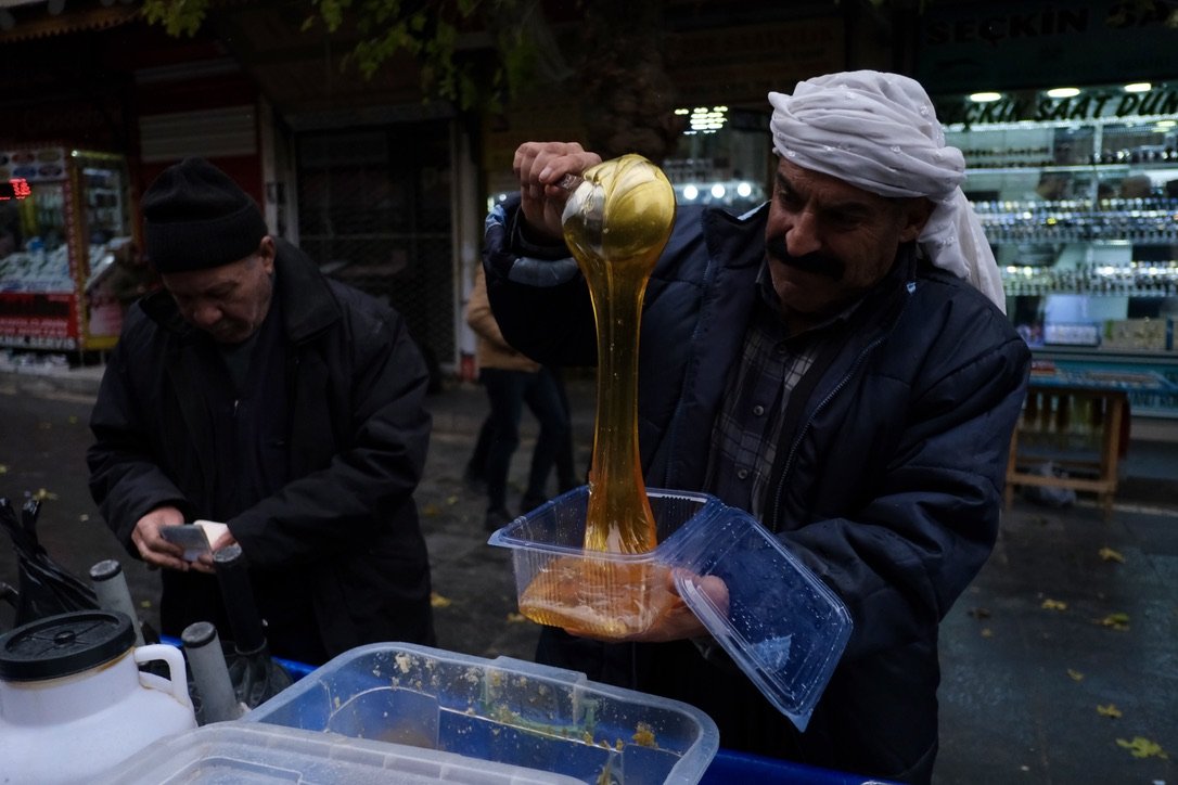
The undamaged parts of Sur are comprised of tiny, ancient roads, lined with sweet and spice shops, totally inhospitable to modern cars. Park your car, and if you do one thing in Diyarbakir, eat liver in the covered market. If you do two things, head to the bazaar to peruse spices, copper and fabric.
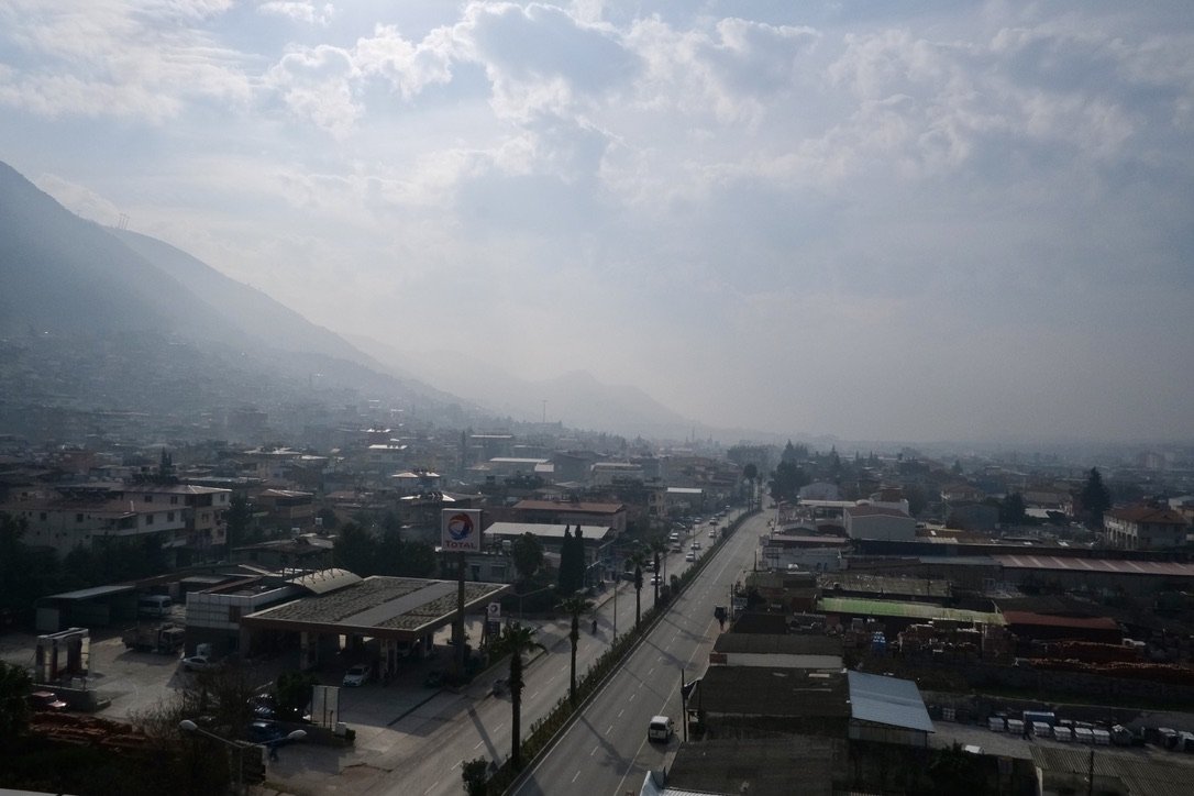
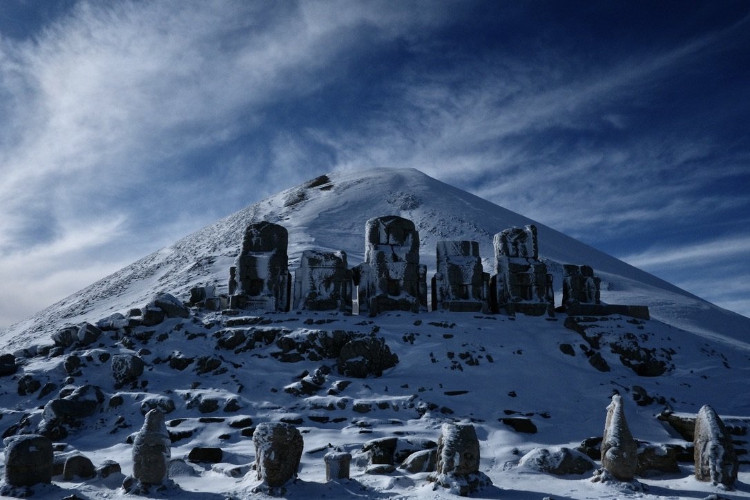
Drive the straight, flat road out of Diyarbakir through rubbled land. This is land that in its shells of buildings and villages, rubble, and soundless towns tells you of its conflict. But beyond the grayish towns and cities, snowcapped mountains reach towards a bluebird sky. This is where you are heading - to Mount Nemrut, home to the mausoleum of Antiochus I, topped with giant carved heads and statues over two thousand years old. The road to Nemrut begins to turn, winding through the foothills of the Taurus mountains. If you’re driving in the summer, you can drive up to the visitor’s centre on the mountain. But, if you’re traveling in the winter, as we were, be prepared to hike. The road in the winter is often covered in snow and ice, and you will have to tuck your car on the side of the road and continue on foot.
At the top of the mountain, take the leftmost path. That will take you to the Western temple - home of the famed fallen heads of Antiochus - then cross over the peak to the Eastern temple. Here, sit for a moment and take in the majesty of the now-headless statues of gods and king Antiochus, holding court over snowy peaks.
From Nemrut, drive towards Syria to the ancient city of Antakya (Antioch). Explore the city - home to some of the earliest christians - and marvel in its many mosaics and ruins. From the city, drive to the coast to Samandag. The beach town is home to Titus’ tunnel, a massive hand-carved tunnel dating from the Roman area. Watch the sun set over the Syrian hills on the shore, then drive through the wooded hills for a glimpse at the Syrian border in the evening light. Security is surprisingly light, and the towns along the border serene. The hills that stretch towards no-man’s-land are a patchwork of vibrant green and the deep red-brown of Mesopotamian soil.
For the more daring - perhaps voyeuristic - among us, take the road from Antakya to Antep along the grey Syrian border wall, marked by heavily armed checkpoints and lookout stations. Drive through Kilis, and you’ll find one of the main entry points to Syria during the decade-long war, where many Daesh fighters came to join the Islamic state. The fighting and transit of soldiers have calmed, but the city still bears the grim demeanour of a place that has seen conflict.
From Kilis, drive to Gaziantep along the border. This was historically an Armenian and Arab city, though now much of the non-Muslim community has left. Markers remain, if somewhat hidden: a large Armenian church in the centre of the city has been converted into a “Liberation Mosque,” and other churches are still riddled with bullet holes from conflict a hundred years ago. Like Sur, it is not city friendly to the motorised vehicle - park and continue on foot.
In Antep, above all, eat the food. Though the city’s UNESCO-certified specialties are countless, don’t miss out on its most famous dishes - beyran, a spicy meat soup, katmer, a pistachio and cream pastry, and anything made with pistachios. Wander through the city’s famed covered markets, stuffed with spices and leather shoes and copper pots, to work off your (many) meals.
Continue along the border from Antep, through Urfa, where you stop for a quick kebab and wander through the city’s covered market, to Mardin, one of the oldest continuously settled cities in the world. The citadel is perched atop a mountain, lush plains stretching to the Syrian border below. The city is all sandstone and arches and crooked passageways, remnants of a different era.
Navigate your car - if it’s small - down the ancient city’s winding roads to one of the many hotels built into the hillside. The architecture that defines the city is Artuklu and Armenian, interlocking passageways, stairways, roads, and connected buildings blanketing the hillside. Mardin is a city that rewards the keenly observant. As you explore the old city - on foot - keep your eyes peeled for the symbols that belie the city’s Armenian, Arab, Assyrian, Kurdish, and Artuklu past. While in Mardin, visit the city’s museum and drive to the ancient city of Dara, where you can see a newly-excavated mass grave - allegedly Roman.
To see clearly the remnants of regional conflict, stop at the border town of Nusaybin (Nisibis), on your way back to Mardin. Nusaybin was both a transit point during the height of the Syrian war and the target of some of the most extreme violence and bombings during the Turkish “city wars” against the PKK in 2015. The city bears the marks of this violence - much of its downtown was demolished - but also has maintained the markers of its rich cultural history. Just near the entrance to Qamishli, visit St. Jacob’s church, still inhabited by the city’s single remaining Assyrian Christian family, and now a UNESCO world heritage site.
As you drive through Mardin to Diyarbakir, winding through dramatic sandstone cliffs, Zerzrvan castle, a Roman citadel, will appear on a hilltop next to the highway. Veer off and climb up the hill to wander the ruins, making sure not to miss the Mithraic temple buried beneath the citadel - one of few remaining vestiges of a mysterious, pre-Christian Roman religion. To see the best of Zerzevan, arrive as the sun is setting. Close out the trip driving back to Diyarbakir through the pitch-black hills, making sure to look up for the stars.
Words & Photography Erin O’Brien Twitter