
Detour #97: Cabot Trail, Cape Breton, Canada

At one turn Cape Breton Island will do a very passable impression of a southern California coastline, at another, you’d swear the west of Scotland has cut loose and floated across the Atlantic, reckons Gavin Conway.
For a drive that you won’t ever forget, take the Cabot Trail, which traces a circular route that goes straight through the Cape Breton Highlands National Park. Along the way you’ll encounter mountains, endless sandy beaches, whales breaching the waves close to shore, majestic bald eagles and a culture that takes in Mi’kmaq native Canadian, French and Scottish influences.
Ideally, you'll need a car with proper power – there are valleys that have the most ludicrous inclines imaginable, many of them dotted with lumbering motorhomes, mountain passes that twist crazily like strands of spaghetti flung at a wall and B-roads with frost heaves and badly-repaired potholes. Not to mention the long, long drive to Cape Breton from the nearest international airport at Halifax that takes you through colossal sweeps of valley that’ll have you driving uphill for what seems an absolute age.
For my own Cape crusade I follow the Canso Causeway from mainland Nova Scotia and onto Cape Breton Island, heading north on Route 19. Clapboard houses stand lonely in the face of an Atlantic gust roiling over the high cliffs. Beside many of these homesteads lie the empty cradles that, in winter, hold the lobster boats that fish right through the high season. I pass the tiny enclaves of Craigmore and Creignish, reminders of the overwhelming Scottish ancestry of the island.

At Inverness on the west coast, I pause. It’s Fishermen’s Day and the whole community has turned out to raise money for the harbour authority. Down by the wharf, most of the parked cars wear out-of-town license plates, from Massachusetts, Rhode Island, Ontario and Alberta. And most of these people aren’t tourists – Cape Bretoners tend to get around a bit, but they’re fiercely loyal to the place. Most return at least once a year.
It’s a festival. From a lobster boat circling the harbour comes the staccato rattle of drums, the baleful moan of bagpipes from a quartet of players. Then an unexpected moment of silence, everybody standing rigidly to attention. From a makeshift timber stage by the wharf, a woman begins singing ‘Oh Canada’ in Gaelic. She finishes and the crowd relaxes, done with its momentary reverence. Then, a teenage girl climbs to the stage and with a great flourish, begins sawing out a violin reel, foot thumping time on the rough stage. Squealing children tear about the place and the longest queue is reserved for the crab burger tent. It’s well worth the wait.

Post crab lunch, I cut east across the island, past Lake Ainslie, a huge freshwater lake popular with windsurfers. Then on to the Bras d’Or Lake, which is effectively an inland sea, home to a one of the largest populations of Bald Eagles in north America. Hang around long enough and you’ll catch one wheeling on the thermals. Beautiful.
Heading north on Cape Breton’s Eastern Shore, I join the Cabot Trail, so named after adventurer John Cabot who staked Britain’s claim to North America here in 1497. I drive through dense forest, the smell of pine filling the car's cabin, and a splash of brilliant white clapboard as yet another small, steepled church stands square and upright against the lush, green wilderness.
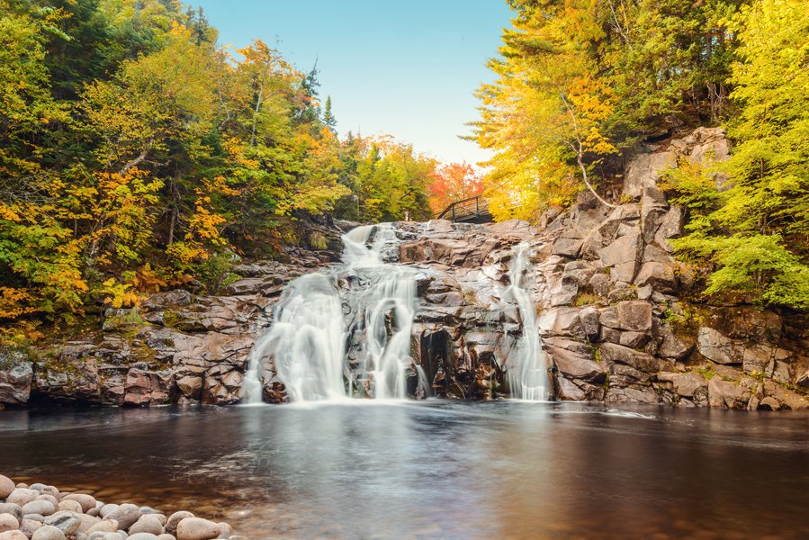
Soon, I’m at the gates of the Cape Breton Highlands National Park. A fabulous collection of hiking trails, waterfalls and sandy beaches, the Park is also home to black bears. As I enter, a ranger hands me a pamphlet explaining how best to handle a bear encounter. It points out that they are much quicker than humans, so running away is pointless. They’re also quite good at climbing trees, so forget that. The advice – which ranks right up there with punching an attacking shark on the nose – suggests speaking quietly and calmly and walking backwards. Better pray he’s a vegetarian while you’re at it.
The approach to the park takes me over Cape Smokey, which rises 1200 feet over a comically twisting road. A breathtaking view over the limitless Atlantic beckons beyond the battered Armco – lots of evidence that enjoying the scenery for a split second too long has consequences.
The run from Cape North to Red River takes in more challenging mountainous roads. This is bigger country, though, with heart-stopping vistas and deep alpine valleys framing the distant, cobalt Atlantic. As I sweep down past Red River and on to the very edge of the coast, the scenery changes dramatically.
For miles ahead of me, the road undulates gently alongside the cliffs that yield to the pounding surf. It is a simple but grand landscape, inspiring a typical Canadian understatement in place names like Pleasant Bay. It’s a bit more than ‘pleasant’, actually.
And then the west coast of Cape Breton reveals a bit more; place names like Belle Marche and Petit Etang speak of a different past. In 1710, Acadia – effectively, the Maritime provinces – passed from France to England as a prize of war. And in 1755, the British decided to expel the Acadians by force. A large contingent of those exiled Acadians ended up in Louisiana and, over the decades that followed, evolved into a new ethnic group. The Cajuns.
Many French Acadians eventually came back – indeed, some of the hardier ones never left – infusing Cape Breton with yet another cultural seam. Rolling into Cheticamp, I come across the Acadian National Flag, which is effectively a French tri-colour with an added gold star to give it that Acadian distinction.
Alongside the Mackay and Macdonald nameplates on post boxes, I see Boudreauxs and Bellangers. And in the local community halls on a Friday night, when the violins and squeezeboxes are broken out, you can hear the sound of a spirit that comes straight out of old New Orleans.

I follow the Cabot Trail south until it becomes Route 19 again, heading south along the coast, past Chimney Corner, St Rose, and Mabou Mines. Locals peer at me from under the peaks of Caterpillar, Molson Canadian or John Deere-liveried baseball caps. And they wave and smile as I pass. Always.
Too soon, I’m at the Canso Causeway again, pointing the car's muzzle southwest toward Halifax.
And then it occurs to me. If I continue west on the Trans Canada highway at the Truro junction instead of cutting south to Halifax International Airport, I can make it to the Canadian west coast in three days tops.
Vancouver, here I come.
Words Gavin Conway Twitter | Instagram
Photography Shutterstock / Elyse Turton / Brand Sehl / Unsplash